
EASTERN DESERT Cracraft 1991
EASTERN DESERT Cracraft 1991
Available Names:
Eastern Desert Cracraft 1991: 214.
Additional synonomies:
Eastern Desert — Crisp et al. 1995: 460, (Pilbara [in part] Cracraft 1991: 214), (Pilbara [in part] Crisp et al. 1995: 460)
Area Taxonomy:
TERRESTRIAL PHYTOGEOGRAPHICAL AREAS
Sub-Realm:
AUSTRALIA (de Candolle 1820)
Region:
EREMAEAN Tate 1889
Sub-Region:
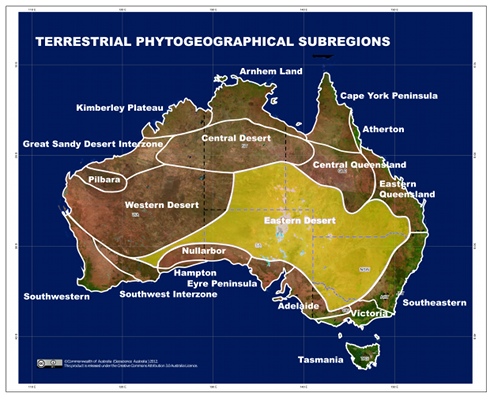
EASTERN DESERT Cracraft 1991
Diagnosis:
The area bounded by the Southwest Australian and Euronotian in the south and southeast respectively, and Eastern Queensland in the east. The northern boundary extends from the western part of the Great Dividing Range near Longreach, Queensland to the Dulcie Ranges in the Northern Territory, to the Petermann Ranges. The Western boundary extends into Western Australia as far as Kalgoolie.
Type-locality:
Nappa Merrie Breakaways, Queensland, Australia, 27°23'7.24"S 141° 9'51.81"E.
The Eastern Desert is extended much farther west, south and southeast since it was first proposed by
Cracraft (1991). Like the Western Desert, its northern extent has been reduced based on the findings of GonzálezOrozco,
Ebach et al. (2014).
Map:
There is currently no additional content associated with this term.