
CAPE YORK PENINSULA Cracraft 1991
CAPE YORK PENINSULA Cracraft 1991
Available Names:
Cape York Peninsula Cracraft 1991: 213.
Additional synonomies:
(Cape York Peninsula Bowman et al. 2010: 203)
Area Taxonomy:
TERRESTRIAL PHYTOGEOGRAPHICAL AREAS
Sub-Realm:
AUSTRALIA (de Candolle 1820)
Region:
EURONOTIAN Tate 1889
Sub-Region:
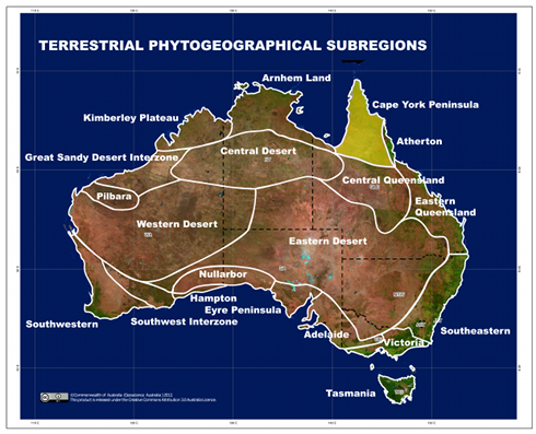
CAPE YORK PENINSULA Cracraft 1991
Diagnosis:
The area lying north between Cooktown and Hughenden, Queensland, extends west toward the Leichhardt and Nicholson Rivers in Queensland.
Type-locality:
Mcilwraith Range, Coen, Queensland, Australia, 13°46'27.00"S 143°19'18.00"E.
Cape York Peninsula has been extended south toward the southwestern end of the Great Dividing
Range between Hughenden and Cloncurry, Queensland. The sub-region extends northwest towards the Leichhardt and
Nicholson Rivers in Queensland. The analysis by González-Orozco, Ebach et al. (2014) shows that the Leichhardt and
Nicholson Rivers may form an overlap zone between the Cape York and Arnhem Land sub-regions.
Map:
There is currently no additional content associated with this term.